France Volcanoes
-
Pelee
-
Piton de la Fournaise
-
Soufriere Guadeloupe
-
Pelee
-

Pelee
-
Piton de la Fournaise
-
Pelee
-
Piton de la Fournaise
-
Pelee
-
Soufriere Guadeloupe
-
Pelee
-
Soufriere Guadeloupe
-

Piton de la Fournaise
-
Soufriere Guadeloupe
-

Pelee
-

Kerguelen Islands
-
Piton de la Fournaise
-
Pelee
-
Piton de la Fournaise
-
Piton de la Fournaise
France has 19 Holocene volcanoes. Note that as a scientific organization we provide these listings for informational purposes only, with no international legal or policy implications. Volcanoes will be included on this list if they are within the boundaries of a country, on a shared boundary or area, in a remote territory, or within a maritime Exclusive Economic Zone. Bolded volcanoes have erupted within the past 20 years. Suggestions and data updates are always welcome ().
| Volcano Name | Location | Last Eruption | Primary Volcano Type |
|---|---|---|---|
| Amsterdam Island | Indian Ocean (southern) | Unknown - Evidence Credible | Stratovolcano |
| Boomerang Seamount | Indian Ocean (southern) | 1995 CE | Caldera |
| Chaine des Puys | France | 4040 BCE | Lava dome(s) |
| Ile aux Cochons | Crozet Islands | Unknown - Evidence Credible | Stratovolcano |
| Ile de l' Est | Crozet Islands | Unknown - Evidence Uncertain | Stratovolcano |
| Piton de la Fournaise | Reunion Island (France) | 2023 CE | Shield |
| Hunter Island | New Caledonia (France) | 1903 CE | Stratovolcano |
| Kerguelen Islands | Kerguelen Plateau | Unknown - Evidence Uncertain | Stratovolcano(es) |
| Macdonald | Austral Islands | 1989 CE | Shield |
| Matthew Island | New Caledonia (France) | 1956 CE | Stratovolcano |
| Mayotte | Comore Islands | 2019 CE | Shield |
| Mehetia | Society Islands | Unknown - Evidence Credible | Stratovolcano |
| Moua Pihaa | Society Islands | 1970 CE | Stratovolcano |
| Pelee | Martinique (France) | 1932 CE | Stratovolcano |
| Ile de la Possession | Crozet Islands | Unknown - Evidence Credible | Stratovolcano |
| Rocard | Society Islands | 1972 CE | Cone |
| Soufriere Guadeloupe | Guadeloupe (France) | 1977 CE | Stratovolcano |
| St. Paul | Indian Ocean (southern) | 1793 CE | Stratovolcano |
| Teahitia | Society Islands | 1985 CE | Compound |
Chronological listing of known Holocene eruptions (confirmed or uncertain) from volcanoes in France. Bolded eruptions indicate continuing activity.
| Volcano Name | Start Date | Stop Date | Certainty | VEI | Evidence |
|---|---|---|---|---|---|
| Piton de la Fournaise | 2023 Jul 2 | 2023 Aug 10 | Confirmed | Observations: Reported | |
| Piton de la Fournaise | 2022 Sep 19 | 2022 Oct 5 | Confirmed | 0 | Observations: Reported |
| Piton de la Fournaise | 2021 Dec 22 | 2022 Jan 17 | Confirmed | 0 | Observations: Seismicity |
| Piton de la Fournaise | 2021 Apr 9 | 2021 May 24 | Confirmed | 0 | Observations: Seismicity |
| Piton de la Fournaise | 2020 Dec 7 | 2020 Dec 8 | Confirmed | 0 | Observations: Seismicity |
| Piton de la Fournaise | 2020 Feb 10 | 2020 Apr 6 | Confirmed | 0 | Observations: Seismicity |
| Piton de la Fournaise | 2019 Jun 11 | 2019 Oct 27 | Confirmed | 0 | Observations: Seismicity |
| Piton de la Fournaise | 2019 Feb 18 | 2019 Mar 10 | Confirmed | 0 | Observations: Seismicity |
| Mayotte | 2018 Jul 3 | 2019 Aug 20 (?) | Confirmed | Observations: Seismicity | |
| Piton de la Fournaise | 2018 Apr 3 | 2018 Nov 1 | Confirmed | 0 | Observations: Seismicity |
| Piton de la Fournaise | 2017 Jul 14 | 2017 Aug 28 | Confirmed | 0 | Observations: Seismicity |
| Piton de la Fournaise | 2017 Jan 31 | 2017 Feb 27 | Confirmed | 0 | Observations: Seismicity |
| Piton de la Fournaise | 2016 Sep 11 | 2016 Sep 18 | Confirmed | 0 | Observations: Seismicity |
| Piton de la Fournaise | 2016 May 26 | 2016 May 27 | Confirmed | 0 | Observations: Seismicity |
| Piton de la Fournaise | 2015 May 17 | 2015 Oct 31 | Confirmed | 0 | Observations: Seismicity |
| Piton de la Fournaise | 2015 Feb 4 | 2015 Feb 15 | Confirmed | 0 | Observations: Reported |
| Piton de la Fournaise | 2014 Jun 21 | 2014 Jun 21 | Confirmed | 0 | Observations: Photo / Video |
| Piton de la Fournaise | 2010 Oct 14 | 2010 Dec 10 | Confirmed | 0 | Observations: Reported |
| Piton de la Fournaise | 2009 Nov 5 | 2010 Jan 12 | Confirmed | 0 | Observations: Reported |
| Piton de la Fournaise | 2008 Sep 12 | 2009 Feb 4 | Confirmed | 0 | Observations: Reported |
| Piton de la Fournaise | 2006 Jul 20 | 2007 May 1 | Confirmed | 1 | Observations: Reported |
| Piton de la Fournaise | 2005 Oct 4 | 2006 Jan 18 | Confirmed | 0 | Observations: Reported |
| Piton de la Fournaise | 2005 Feb 17 | 2005 Feb 26 | Confirmed | 0 | Observations: Reported |
| Piton de la Fournaise | 2004 May 2 | 2004 Oct 14 | Confirmed | 1 | Observations: Reported |
| Piton de la Fournaise | 2003 May 30 | 2004 Jan 10 | Confirmed | 0 | Observations: Reported |
| Piton de la Fournaise | 2002 Nov 16 | 2002 Dec 23 | Confirmed | 1 | Observations: Reported |
| Piton de la Fournaise | 2002 Jan 5 | 2002 Jan 16 | Confirmed | 0 | Observations: Reported |
| Piton de la Fournaise | 2001 Mar 27 | 2001 Jul 7 | Confirmed | 0 | Observations: Reported |
| Piton de la Fournaise | 2000 Jun 23 | 2000 Nov 13 | Confirmed | 1 | Observations: Reported |
| Piton de la Fournaise | 2000 Feb 14 | 2000 Mar 4 | Confirmed | 0 | Observations: Reported |
| Piton de la Fournaise | 1999 Jul 19 | 1999 Oct 23 | Confirmed | 0 | Observations: Seismicity |
| Piton de la Fournaise | 1998 Mar 9 | 1998 Sep 21 | Confirmed | 0 | Observations: Reported |
| Boomerang Seamount | 1995 Dec 1 ± 30 days | Unknown | Confirmed | 0 | Isotopic: Uranium-series |
| Piton de la Fournaise | 1992 Aug 27 | 1992 Sep 23 | Confirmed | 0 | Observations: Reported |
| Piton de la Fournaise | 1991 Jul 19 | 1991 Jul 20 | Confirmed | 0 | Observations: Seismicity |
| Piton de la Fournaise | 1990 Jan 18 | 1990 May 8 | Confirmed | 0 | Observations: Reported |
| Piton de la Fournaise | 1987 Nov 6 | 1988 Dec 29 | Confirmed | 0 | Observations: Reported |
| Piton de la Fournaise | 1987 Jun 10 | 1987 Jul 20 | Confirmed | 0 | Observations: Reported |
| Macdonald | 1987 Jun 4 | 1989 Jan 28 (in or after) | Confirmed | 0 | Observations: Reported |
| Piton de la Fournaise | 1986 Nov 12 | 1987 Feb 10 | Confirmed | 1 | Observations: Reported |
| Piton de la Fournaise | 1986 Jul 13 | 1986 Jul 14 | Confirmed | 0 | Observations: Reported |
| Macdonald | 1986 May 16 | 1986 Aug 2 | Confirmed | 0 | Observations: Hydrophonic |
| Piton de la Fournaise | 1985 Jun 14 | 1986 Apr 5 | Confirmed | 0 | Observations: Reported |
| Teahitia | 1985 Jan 10 | 1985 Jan 25 | Confirmed | 0 | Observations: Hydrophonic |
| Teahitia | 1983 Dec 18 | 1984 Jul 14 | Confirmed | 0 | Observations: Hydrophonic |
| Piton de la Fournaise | 1983 Dec 4 | 1984 Feb 18 | Confirmed | 2 | Observations: Reported |
| Macdonald | 1983 Oct 27 | 1984 Jan 3 | Confirmed | 0 | Observations: Hydrophonic |
| Teahitia | 1983 Jul 12 | 1983 Jul 26 | Confirmed | 0 | Observations: Hydrophonic |
| Macdonald | 1983 Mar 14 | 1983 May 21 | Confirmed | 0 | Observations: Hydrophonic |
| Teahitia | 1982 Mar 16 | 1982 May 19 | Confirmed | 0 | Observations: Hydrophonic |
| Macdonald | 1982 Mar 1 | 1982 Jun 6 | Confirmed | 0 | Observations: Hydrophonic |
| Mehetia | [1981 Mar 5] | [1981 Dec 16 ± 15 days] | Uncertain | ||
| Piton de la Fournaise | 1981 Feb 3 | 1981 May 5 | Confirmed | 2 | Observations: Reported |
| Macdonald | 1980 Nov 10 | 1981 Feb 15 | Confirmed | 0 | Observations: Hydrophonic |
| Macdonald | 1980 Feb 12 | 1980 Feb 13 | Confirmed | 0 | Observations: Hydrophonic |
| Macdonald | 1979 Sep 30 | 1979 Sep 30 | Confirmed | 0 | Observations: Hydrophonic |
| Piton de la Fournaise | 1979 May 28 | 1979 Jul 14 | Confirmed | 1 | Observations: Reported |
| Macdonald | 1977 Dec 10 | 1977 Dec 15 | Confirmed | 0 | Observations: Hydrophonic |
| Piton de la Fournaise | 1977 Oct 24 | 1977 Nov 17 | Confirmed | 1 | Observations: Reported |
| Piton de la Fournaise | 1977 Mar 24 | 1977 Apr 16 | Confirmed | 0 | Observations: Reported |
| Matthew Island | [1976 Nov 27] | [Unknown] | Uncertain | ||
| Piton de la Fournaise | 1976 Nov 2 | 1976 Nov 4 (?) | Confirmed | 1 | Observations: Reported |
| Soufriere Guadeloupe | 1976 Jul 8 | 1977 Mar 1 | Confirmed | 2 | Observations: Reported |
| Piton de la Fournaise | 1975 Nov 4 | 1976 Apr 6 | Confirmed | 1 | Observations: Reported |
| Piton de la Fournaise | 1973 May 10 | 1973 Sep 5 (?) | Confirmed | 2 | Observations: Reported |
| Rocard | 1972 Jul 4 | 1972 Jul 19 | Confirmed | 0 | Observations: Hydrophonic |
| Piton de la Fournaise | 1972 Jun 9 (?) | 1973 Jan 16 (?) | Confirmed | 2 | Observations: Reported |
| Rocard | 1971 Sep 6 | Unknown | Confirmed | 0 | Observations: Hydrophonic |
| Moua Pihaa | 1970 Jun 21 | 1970 Jun 23 | Confirmed | 0 | Observations: Hydrophonic |
| Moua Pihaa | 1969 Apr 22 | 1969 Apr 29 | Confirmed | 0 | Observations: Hydrophonic |
| Macdonald | 1967 May 29 | 1967 May 29 | Confirmed | 0 | Observations: Hydrophonic |
| Matthew Island | [1966 Aug 16 ± 15 days] | [Unknown] | Uncertain | ||
| Piton de la Fournaise | 1966 Mar 15 | 1966 May 15 | Confirmed | 2 | Observations: Reported |
| Rocard | 1966 Mar 9 | 1966 Mar 20 | Confirmed | 0 | Observations: Hydrophonic |
| Piton de la Fournaise | 1964 Dec 21 | 1965 Feb 15 | Confirmed | 2 | Observations: Reported |
| Piton de la Fournaise | 1964 Apr 30 | 1964 May 8 | Confirmed | 2 | Observations: Reported |
| Piton de la Fournaise | 1963 Nov 7 | 1963 Nov 21 | Confirmed | 2 | Observations: Reported |
| Matthew Island | [1963 Sep 11] | [1964 Jul 2 ± 182 days] | Uncertain | ||
| Piton de la Fournaise | 1961 Apr 5 | 1961 Apr 25 | Confirmed | 0 | Observations: Reported |
| Piton de la Fournaise | 1960 Jan 11 | 1960 Mar 10 | Confirmed | 2 | Observations: Reported |
| Piton de la Fournaise | 1959 Mar 11 | 1959 Aug 6 | Confirmed | 2 | Observations: Reported |
| Piton de la Fournaise | 1958 May 30 | 1958 Sep 20 | Confirmed | 2 | Observations: Reported |
| Piton de la Fournaise | 1957 Sep 2 | 1957 Nov 16 | Confirmed | 2 | Observations: Reported |
| Soufriere Guadeloupe | 1956 Oct 19 | 1956 Oct 27 | Confirmed | 1 | Observations: Reported |
| Matthew Island | 1956 Jul 2 ± 2 years ± 182 days | Unknown | Confirmed | 0 | Observations: Reported |
| Piton de la Fournaise | 1955 Jul 6 | 1957 Mar 16 | Confirmed | 2 | Observations: Reported |
| Matthew Island | 1954 Oct 16 (?) ± 15 days | Unknown | Confirmed | 2 | Observations: Reported |
| Piton de la Fournaise | 1954 Jan 16 ± 15 days | 1954 Dec 16 ± 15 days | Confirmed | Observations: Reported | |
| Piton de la Fournaise | 1953 Mar 13 | 1953 Jul 8 | Confirmed | 2 | Observations: Reported |
| Piton de la Fournaise | 1952 May 19 | 1952 Jul 20 | Confirmed | 2 | Observations: Reported |
| Piton de la Fournaise | 1951 Sep 10 | 1951 Sep 20 | Confirmed | 1 | Observations: Reported |
| Piton de la Fournaise | [1951 Jun 16 ± 15 days] | [Unknown] | Uncertain | ||
| Piton de la Fournaise | 1950 Aug 30 | 1950 Sep 5 | Confirmed | 2 | Observations: Reported |
| Piton de la Fournaise | 1950 Feb 25 | 1950 Apr 2 | Confirmed | 2 | Observations: Reported |
| Piton de la Fournaise | [1949 Oct] | [Unknown] | Uncertain | ||
| Matthew Island | 1949 (in or before) | Unknown | Confirmed | 2 | Observations: Reported |
| Piton de la Fournaise | 1948 Feb 14 | 1948 Mar 8 | Confirmed | 2 | Observations: Reported |
| Piton de la Fournaise | 1947 (?) | Unknown | Confirmed | 2 | Observations: Reported |
| Piton de la Fournaise | 1946 Jun 18 | 1946 Jul 5 | Confirmed | 2 | Observations: Reported |
| Piton de la Fournaise | 1945 Apr 15 | 1945 May 6 | Confirmed | 2 | Observations: Reported |
| Piton de la Fournaise | 1944 Apr 11 | 1944 May 1 | Confirmed | 2 | Observations: Reported |
| Piton de la Fournaise | 1943 Mar 30 (?) | 1943 May 26 ± 5 days | Confirmed | 2 | Observations: Reported |
| Piton de la Fournaise | 1942 Oct 5 | 1942 Oct 25 | Confirmed | 2 | Observations: Reported |
| Piton de la Fournaise | 1941 (?) | Unknown | Confirmed | 1 | Observations: Reported |
| Piton de la Fournaise | 1938 Dec 7 | 1939 Jan 15 | Confirmed | 2 | Observations: Reported |
| Piton de la Fournaise | 1938 Jul 25 | 1938 Jul 29 | Confirmed | 1 | Observations: Reported |
| Piton de la Fournaise | 1937 Aug 13 | 1937 Nov 25 | Confirmed | 2 | Observations: Reported |
| Piton de la Fournaise | 1936 Sep | Unknown | Confirmed | 0 | Observations: Reported |
| Macdonald | [1936] | [Unknown] | Uncertain | ||
| Piton de la Fournaise | 1935 (?) | Unknown | Confirmed | 2 | Observations: Reported |
| Piton de la Fournaise | 1933 Jun 7 | 1934 Apr 1 | Confirmed | 2 | Observations: Reported |
| Piton de la Fournaise | 1932 Nov 14 ± 14 days | 1932 Nov 16 ± 14 days | Confirmed | Observations: Reported | |
| Piton de la Fournaise | 1931 Jan 22 | 1931 Aug 26 ± 5 days | Confirmed | 2 | Observations: Reported |
| Piton de la Fournaise | 1930 May 23 | 1930 May 24 | Confirmed | 0 | Observations: Reported |
| Piton de la Fournaise | 1929 Dec 23 | 1929 Dec 31 | Confirmed | 2 | Observations: Reported |
| Pelee | 1929 Sep 16 | 1932 Dec 1 ± 30 days | Confirmed | 3 | Observations: Reported |
| Macdonald | [1928] | [Unknown] | Uncertain | ||
| Piton de la Fournaise | 1926 Sep 18 | 1927 Jun 15 | Confirmed | 2 | Observations: Reported |
| Piton de la Fournaise | 1925 Dec 30 | 1926 Apr 20 | Confirmed | 2 | Observations: Reported |
| Piton de la Fournaise | 1924 Sep 3 | 1924 Sep 13 | Confirmed | 2 | Observations: Reported |
| Piton de la Fournaise | 1924 May 19 | 1924 May 23 (in or after) | Confirmed | 0 | Observations: Reported |
| Piton de la Fournaise | 1921 Nov 27 | 1921 Dec 3 | Confirmed | 2 | Observations: Reported |
| Piton de la Fournaise | 1920 Jun 28 | 1920 Oct 18 | Confirmed | 0 | Observations: Reported |
| Piton de la Fournaise | 1917 Apr 29 | 1917 Apr 29 | Confirmed | 0 | Observations: Reported |
| Piton de la Fournaise | 1915 Jul 22 | 1915 Nov 21 | Confirmed | 2 | Observations: Reported |
| Piton de la Fournaise | 1913 Jul 10 | 1913 Aug 3 | Confirmed | 2 | Observations: Reported |
| Piton de la Fournaise | 1910 Nov 16 | 1910 Dec 12 | Confirmed | 2 | Observations: Reported |
| Piton de la Fournaise | 1909 Apr | Unknown | Confirmed | 2 | Observations: Reported |
| Piton de la Fournaise | [1908] | [Unknown] | Uncertain | ||
| Piton de la Fournaise | 1907 Nov 29 | 1907 Dec 5 ± 4 days | Confirmed | 0 | Observations: Reported |
| Piton de la Fournaise | 1905 Feb 15 | 1905 Feb 16 | Confirmed | 2 | Observations: Reported |
| Piton de la Fournaise | 1904 Aug 19 | 1904 Oct 17 | Confirmed | 2 | Observations: Reported |
| Soufriere Guadeloupe | [1903] | [Unknown] | Uncertain | ||
| Piton de la Fournaise | 1903 (?) | Unknown | Confirmed | 0 | Observations: Reported |
| Hunter Island | 1903 | Unknown | Confirmed | 0 | Observations: Reported |
| Piton de la Fournaise | 1902 Aug 13 | 1902 Aug 18 | Confirmed | 2 | Observations: Reported |
| Pelee | 1902 Apr 23 | 1905 Oct 5 | Confirmed | 4 | Observations: Reported |
| Piton de la Fournaise | 1901 Jul 4 | 1901 Jul 6 | Confirmed | 2 | Observations: Reported |
| Piton de la Fournaise | 1901 Feb 21 | 1901 Feb 25 | Confirmed | 2 | Observations: Reported |
| Piton de la Fournaise | 1900 May 11 | 1900 May 30 | Confirmed | 0 | Observations: Reported |
| Piton de la Fournaise | 1899 Feb 13 | 1899 Jul 18 (in or after) | Confirmed | 2 | Observations: Reported |
| Piton de la Fournaise | 1898 Nov 26 | Unknown | Confirmed | 2 | Observations: Reported |
| Piton de la Fournaise | 1898 Jan 14 | 1898 Jan 20 | Confirmed | 2 | Observations: Reported |
| Piton de la Fournaise | 1897 Jan 5 ± 4 days | 1897 Jan 24 | Confirmed | 0 | Observations: Reported |
| Hunter Island | 1895 Nov 24 | Unknown | Confirmed | Observations: Reported | |
| Piton de la Fournaise | 1894 Aug | Unknown | Confirmed | 2 | Observations: Reported |
| Hunter Island | [1892] | [Unknown] | Uncertain | ||
| Piton de la Fournaise | 1890 Feb | 1891 Feb 4 | Confirmed | 2 | Observations: Reported |
| Piton de la Fournaise | 1889 Jun | 1889 Aug 11 (in or after) | Confirmed | 2 | Observations: Reported |
| Piton de la Fournaise | 1884 Feb 4 | 1884 Feb 5 | Confirmed | 0 | Observations: Reported |
| Piton de la Fournaise | [1882] | [Unknown] | Uncertain | ||
| Piton de la Fournaise | 1878 Mar 14 | 1878 Mar 30 | Confirmed | 0 | Observations: Reported |
| Piton de la Fournaise | 1876 Dec 11 | 1876 Dec 11 (?) | Confirmed | Observations: Reported | |
| Piton de la Fournaise | 1875 Nov 26 | 1875 Dec 11 (?) | Confirmed | 0 | Observations: Reported |
| Piton de la Fournaise | 1874 Jun 29 | 1874 Nov 7 (in or after) | Confirmed | 2 | Observations: Reported |
| Piton de la Fournaise | 1874 Feb 1 ± 30 days | Unknown | Confirmed | Observations: Reported | |
| Piton de la Fournaise | [1872 Feb 1 ± 30 days] | [Unknown] | Uncertain | ||
| Piton de la Fournaise | 1871 Jun 21 | 1871 Jul 5 | Confirmed | 0 | Observations: Reported |
| Piton de la Fournaise | [1870 Feb 1 ± 30 days] | [Unknown] | Uncertain | ||
| Piton de la Fournaise | 1869 (?) | Unknown | Confirmed | 2 | Observations: Reported |
| Piton de la Fournaise | 1868 Mar | Unknown | Confirmed | 0 | Observations: Reported |
| Piton de la Fournaise | 1865 Feb 5 | 1865 Feb 10 | Confirmed | 2 | Observations: Reported |
| Piton de la Fournaise | 1863 Dec 20 | 1864 Jan 29 | Confirmed | 0 | Observations: Reported |
| Piton de la Fournaise | 1861 Mar 19 | 1861 Mar 19 | Confirmed | 2 | Observations: Reported |
| Piton de la Fournaise | 1860 Jan 22 | 1860 Mar 20 | Confirmed | 2 | Observations: Reported |
| Piton de la Fournaise | 1859 May 8 | 1859 May 23 (in or after) | Confirmed | 2 | Observations: Reported |
| Piton de la Fournaise | 1858 Nov 3 | 1859 Jan | Confirmed | 2 | Observations: Reported |
| Piton de la Fournaise | 1852 | Unknown | Confirmed | 0 | Observations: Reported |
| Pelee | 1851 Aug 5 | 1852 Feb 1 ± 30 days | Confirmed | 2 | Observations: Reported |
| Piton de la Fournaise | 1851 | Unknown | Confirmed | 0 | Observations: Reported |
| Piton de la Fournaise | 1850 Nov 3 | 1850 Nov 12 | Confirmed | 0 | Observations: Reported |
| Piton de la Fournaise | 1849 | Unknown | Confirmed | 0 | Observations: Reported |
| Piton de la Fournaise | 1848 | Unknown | Confirmed | 0 | Observations: Reported |
| Piton de la Fournaise | 1847 | Unknown | Confirmed | 0 | Observations: Reported |
| Piton de la Fournaise | 1846 | Unknown | Confirmed | 0 | Observations: Reported |
| Piton de la Fournaise | 1845 | Unknown | Confirmed | 0 | Observations: Reported |
| Piton de la Fournaise | 1844 Dec | Unknown | Confirmed | 2 | Observations: Reported |
| Piton de la Fournaise | 1844 Mar 19 | 1844 May 11 | Confirmed | 2 | Observations: Reported |
| Piton de la Fournaise | 1843 | Unknown | Confirmed | 0 | Observations: Reported |
| Piton de la Fournaise | 1842 Apr | Unknown | Confirmed | 0 | Observations: Reported |
| Hunter Island | 1841 Mar 15 | Unknown | Confirmed | Observations: Reported | |
| Soufriere Guadeloupe | 1836 Dec 3 | 1837 Feb 12 | Confirmed | 2 | Observations: Reported |
| Hunter Island | 1835 | Unknown | Confirmed | Observations: Reported | |
| Piton de la Fournaise | 1832 Mar | Unknown | Confirmed | 0 | Observations: Reported |
| Piton de la Fournaise | 1830 Oct | Unknown | Confirmed | 0 | Observations: Reported |
| Matthew Island | [1828 Jan] | [Unknown] | Uncertain | ||
| Piton de la Fournaise | 1824 Dec | Unknown | Confirmed | 0 | Observations: Reported |
| Piton de la Fournaise | 1824 Feb | Unknown | Confirmed | 0 | Observations: Reported |
| Piton de la Fournaise | 1821 Feb 27 | 1821 Apr 10 | Confirmed | 2 | Observations: Reported |
| Piton de la Fournaise | 1820 Jan | 1820 Feb | Confirmed | 2 | Observations: Reported |
| Piton de la Fournaise | 1817 Jan | 1817 Apr | Confirmed | 0 | Observations: Reported |
| Piton de la Fournaise | 1816 Dec 15 | Unknown | Confirmed | 0 | Observations: Reported |
| Piton de la Fournaise | 1815 Aug 15 | 1815 Aug 16 | Confirmed | 2 | Observations: Reported |
| Piton de la Fournaise | 1815 Jan 21 | 1815 Jan 27 | Confirmed | 2 | Observations: Reported |
| Piton de la Fournaise | 1814 Sep 10 | 1814 Oct 13 | Confirmed | 2 | Observations: Reported |
| Piton de la Fournaise | 1813 Sep 26 | 1813 Nov 26 | Confirmed | 2 | Observations: Reported |
| Piton de la Fournaise | 1812 Aug 5 ± 4 days | 1812 Dec | Confirmed | 2 | Observations: Reported |
| Soufriere Guadeloupe | 1812 Apr | 1812 May 10 | Confirmed | 1 | Observations: Reported |
| Piton de la Fournaise | 1810 Nov 20 | 1810 Nov 28 | Confirmed | 0 | Observations: Reported |
| Piton de la Fournaise | 1809 Jul 17 | 1809 Aug 8 | Confirmed | 2 | Observations: Reported |
| Piton de la Fournaise | 1807 Mar 23 | 1807 Jun 13 | Confirmed | 2 | Observations: Reported |
| Piton de la Fournaise | 1802 Dec | Unknown | Confirmed | 2 | Observations: Reported |
| Piton de la Fournaise | 1801 Oct 27 | 1802 Apr 28 ± 7 days | Confirmed | 2 | Observations: Reported |
| Piton de la Fournaise | 1800 Nov 2 | 1800 Nov 8 | Confirmed | 0 | Observations: Reported |
| Soufriere Guadeloupe | 1797 Sep 29 | 1798 Apr 26 (?) | Confirmed | 2 | Observations: Reported |
| Hunter Island | [1797] | [Unknown] | Uncertain | ||
| Piton de la Fournaise | 1797 (?) | Unknown | Confirmed | 0 | Observations: Reported |
| Piton de la Fournaise | 1795 | Unknown | Confirmed | Observations: Reported | |
| Piton de la Fournaise | 1794 Jan | 1794 Jan | Confirmed | 0 | Observations: Reported |
| St. Paul | 1793 | Unknown | Confirmed | 2 | Observations: Reported |
| Piton de la Fournaise | 1792 Dec 19 (?) | Unknown | Confirmed | 0 | Observations: Reported |
| Pelee | 1792 Jan 22 | 1792 Apr (?) | Confirmed | 1 | Observations: Reported |
| Piton de la Fournaise | 1791 Jun 5 ± 4 days | 1791 Jul 27 (?) | Confirmed | 2 | Observations: Reported |
| Piton de la Fournaise | 1789 Jun | 1789 Jul | Confirmed | 2 | Observations: Reported |
| Piton de la Fournaise | 1787 Jun 14 | 1787 Aug 1 | Confirmed | 2 | Observations: Reported |
| Piton de la Fournaise | 1786 Jun 5 (?) | 1786 Aug 4 (in or after) | Confirmed | 2 | Observations: Reported |
| Piton de la Fournaise | 1784 | 1785 | Confirmed | 2 | Observations: Reported |
| Piton de la Fournaise | 1776 | Unknown | Confirmed | 0 | Observations: Reported |
| Piton de la Fournaise | 1775 | Unknown | Confirmed | 2 | Observations: Reported |
| Piton de la Fournaise | 1774 Jul 2 ± 182 days | Unknown | Confirmed | 0 | Observations: Reported |
| Piton de la Fournaise | 1772 Nov 18 | Unknown | Confirmed | 2 | Observations: Reported |
| Piton de la Fournaise | 1772 Feb | Unknown | Confirmed | 2 | Observations: Reported |
| Piton de la Fournaise | 1771 | Unknown | Confirmed | Observations: Reported | |
| Piton de la Fournaise | 1768 | Unknown | Confirmed | 2 | Observations: Reported |
| Piton de la Fournaise | 1766 Mar | 1766 May 26 ± 5 days | Confirmed | 2 | Observations: Reported |
| Piton de la Fournaise | 1760 Dec 15 | 1760 Dec 29 | Confirmed | 2 | Observations: Reported |
| Piton de la Fournaise | 1759 | Unknown | Confirmed | Observations: Reported | |
| Piton de la Fournaise | 1753 | Unknown | Confirmed | 2 | Observations: Reported |
| Piton de la Fournaise | 1751 Jun | 1751 Jun | Confirmed | 2 | Observations: Reported |
| Piton de la Fournaise | 1734 Dec | 1734 Dec | Confirmed | 2 | Observations: Reported |
| Piton de la Fournaise | 1734 Jan 1 | 1734 Mar 6 | Confirmed | 2 | Observations: Reported |
| Piton de la Fournaise | 1733 (?) | Unknown | Confirmed | 0 | Observations: Reported |
| Piton de la Fournaise | 1721 Jun | Unknown | Confirmed | 2 | Observations: Reported |
| Piton de la Fournaise | 1709 | Unknown | Confirmed | 2 | Observations: Reported |
| Piton de la Fournaise | 1708 Apr | 1708 Apr | Confirmed | 0 | Observations: Reported |
| Piton de la Fournaise | 1703 (in or before) | 1705 | Confirmed | 0 | Observations: Reported |
| Soufriere Guadeloupe | [1696 Apr] | [Unknown] | Uncertain | ||
| Soufriere Guadeloupe | 1690 Apr 5 (in or after) | Unknown | Confirmed | 1 | Observations: Reported |
| Piton de la Fournaise | 1672 | Unknown | Confirmed | 0 | Observations: Reported |
| Piton de la Fournaise | 1671 | Unknown | Confirmed | 0 | Observations: Reported |
| Piton de la Fournaise | 1669 | Unknown | Confirmed | 0 | Observations: Reported |
| Piton de la Fournaise | 1649 | Unknown | Confirmed | 0 | Observations: Reported |
| Piton de la Fournaise | 1640 | Unknown | Confirmed | 0 | Observations: Reported |
| Pelee | 1635 (in or before) | Unknown | Confirmed | Observations: Reported | |
| Piton de la Fournaise | 1600 (?) | Unknown | Confirmed | 0 | Isotopic: 14C (calibrated) |
| Soufriere Guadeloupe | 1530 ± 30 years | Unknown | Confirmed | 4 | Isotopic: 14C (calibrated) |
| Pelee | 1460 ± 20 years | Unknown | Confirmed | Isotopic: 14C (uncalibrated) | |
| Piton de la Fournaise | 1440 (?) | Unknown | Confirmed | 0 | Isotopic: 14C (calibrated) |
| Pelee | 1370 (?) | Unknown | Confirmed | Isotopic: 14C (uncalibrated) | |
| Piton de la Fournaise | 1340 (?) | Unknown | Confirmed | 0 | Isotopic: 14C (calibrated) |
| Pelee | 1340 ± 50 years | Unknown | Confirmed | 4 | Isotopic: 14C (calibrated) |
| Pelee | 1260 ± 20 years | Unknown | Confirmed | Isotopic: 14C (uncalibrated) | |
| Pelee | 1190 (?) | Unknown | Confirmed | Isotopic: 14C (uncalibrated) | |
| Piton de la Fournaise | 0960 (?) | Unknown | Confirmed | 0 | Isotopic: 14C (calibrated) |
| Pelee | 0910 (?) | Unknown | Confirmed | Isotopic: 14C (uncalibrated) | |
| Pelee | 0890 ± 100 years | Unknown | Confirmed | 4 | Isotopic: 14C (calibrated) |
| Pelee | 0720 (?) | Unknown | Confirmed | Isotopic: 14C (uncalibrated) | |
| Pelee | 0650 (?) | Unknown | Confirmed | Isotopic: 14C (uncalibrated) | |
| Piton de la Fournaise | 0600 (?) | Unknown | Confirmed | 0 | Isotopic: 14C (calibrated) |
| Piton de la Fournaise | 0455 (?) | Unknown | Confirmed | 0 | Isotopic: 14C (uncalibrated) |
| Pelee | 0450 (?) | Unknown | Confirmed | 4 | Isotopic: 14C (uncalibrated) |
| Soufriere Guadeloupe | 0370 ± 75 years | Unknown | Confirmed | Isotopic: 14C (calibrated) | |
| Pelee | 0350 ± 75 years | Unknown | Confirmed | 4 | Isotopic: 14C (calibrated) |
| Pelee | 0300 (?) | Unknown | Confirmed | 4 | Isotopic: 14C (uncalibrated) |
| Pelee | 0220 ± 75 years | Unknown | Confirmed | Isotopic: 14C (uncalibrated) | |
| Pelee | 0130 (?) | Unknown | Confirmed | 4 | Isotopic: 14C (uncalibrated) |
| Piton de la Fournaise | 0120 (?) | Unknown | Confirmed | 0 | Isotopic: 14C (calibrated) |
| Pelee | 0050 (?) | Unknown | Confirmed | 4 | Isotopic: 14C (uncalibrated) |
| Pelee | 0010 ± 50 years | Unknown | Confirmed | 4 | Isotopic: 14C (calibrated) |
| Pelee | 0200 BCE (?) | Unknown | Confirmed | 4 | Isotopic: 14C (uncalibrated) |
| Pelee | 0300 BCE ± 100 years | Unknown | Confirmed | Isotopic: 14C (calibrated) | |
| Pelee | 0440 BCE (?) | Unknown | Confirmed | 4 | Isotopic: 14C (uncalibrated) |
| Soufriere Guadeloupe | 0580 BCE (after) | Unknown | Confirmed | 2 | Isotopic: 14C (uncalibrated) |
| Pelee | 0590 BCE ± 200 years | Unknown | Confirmed | 4 | Isotopic: 14C (calibrated) |
| Pelee | 0600 BCE (?) | Unknown | Confirmed | Isotopic: 14C (uncalibrated) | |
| Pelee | 0620 BCE (?) | Unknown | Confirmed | Isotopic: 14C (uncalibrated) | |
| Pelee | 0730 BCE (?) | Unknown | Confirmed | Isotopic: 14C (uncalibrated) | |
| Soufriere Guadeloupe | 0820 BCE ± 100 years | Unknown | Confirmed | 3 | Isotopic: 14C (calibrated) |
| Pelee | 0890 BCE ± 50 years | Unknown | Confirmed | Isotopic: 14C (calibrated) | |
| Soufriere Guadeloupe | 0980 BCE ± 200 years | Unknown | Confirmed | Isotopic: 14C (calibrated) | |
| Soufriere Guadeloupe | 1310 BCE ± 150 years | Unknown | Confirmed | 3 | Isotopic: 14C (calibrated) |
| Pelee | 1390 BCE ± 150 years | Unknown | Confirmed | Isotopic: 14C (calibrated) | |
| Piton de la Fournaise | 1785 BCE ± 90 years | Unknown | Confirmed | Isotopic: 14C (uncalibrated) | |
| Soufriere Guadeloupe | 1810 BCE ± 150 years | Unknown | Confirmed | Isotopic: 14C (calibrated) | |
| Mayotte | 2050 BCE ± 500 years | Unknown | Confirmed | Correlation: Tephrochronology | |
| Soufriere Guadeloupe | [2050 BCE (?)] | [Unknown] | Uncertain | ||
| Pelee | 2100 BCE ± 200 years | Unknown | Confirmed | Isotopic: 14C (calibrated) | |
| Pelee | 2280 BCE (?) | Unknown | Confirmed | Isotopic: 14C (uncalibrated) | |
| Pelee | 2360 BCE (?) | Unknown | Confirmed | Isotopic: 14C (uncalibrated) | |
| Pelee | 2430 BCE (?) | Unknown | Confirmed | 4 | Isotopic: 14C (uncalibrated) |
| Pelee | 2460 BCE ± 100 years | Unknown | Confirmed | Isotopic: 14C (calibrated) | |
| Pelee | 2660 BCE ± 200 years | Unknown | Confirmed | 4 | Isotopic: 14C (calibrated) |
| Piton de la Fournaise | 2765 BCE ± 145 years | Unknown | Confirmed | 5 | Isotopic: 14C (uncalibrated) |
| Piton de la Fournaise | 2795 BCE ± 130 years | Unknown | Confirmed | Isotopic: 14C (uncalibrated) | |
| Pelee | 3020 BCE (?) | Unknown | Confirmed | Isotopic: 14C (uncalibrated) | |
| Pelee | 3120 BCE ± 200 years | Unknown | Confirmed | Isotopic: 14C (calibrated) | |
| Pelee | 3250 BCE (?) | Unknown | Confirmed | Isotopic: 14C (uncalibrated) | |
| Pelee | 3290 BCE (?) | Unknown | Confirmed | Isotopic: 14C (uncalibrated) | |
| Soufriere Guadeloupe | 3310 BCE ± 150 years | Unknown | Confirmed | Isotopic: 14C (calibrated) | |
| Pelee | 3430 BCE ± 75 years | Unknown | Confirmed | 4 | Isotopic: 14C (calibrated) |
| Pelee | 3500 BCE ± 200 years | Unknown | Confirmed | 4 | Correlation: Tephrochronology |
| Mayotte | 3550 BCE ± 500 years | Unknown | Confirmed | Correlation: Tephrochronology | |
| Pelee | 3820 BCE (?) | Unknown | Confirmed | 4 | Isotopic: 14C (uncalibrated) |
| Pelee | 3930 BCE ± 100 years | Unknown | Confirmed | Isotopic: 14C (calibrated) | |
| Chaine des Puys | 4040 BCE ± 150 years | Unknown | Confirmed | Isotopic: 14C (uncalibrated) | |
| Mayotte | 4050 BCE ± 500 years | Unknown | Confirmed | Correlation: Tephrochronology | |
| Pelee | 4510 BCE ± 500 years | Unknown | Confirmed | Isotopic: 14C (calibrated) | |
| Pelee | 5500 BCE ± 200 years | Unknown | Confirmed | 4 | Isotopic: 14C (calibrated) |
| Chaine des Puys | 5760 BCE (?) | Unknown | Confirmed | Radiogenic: Thermoluminescence | |
| Pelee | 5800 BCE (?) | Unknown | Confirmed | Isotopic: 14C (uncalibrated) | |
| Chaine des Puys | 6020 BCE ± 150 years | Unknown | Confirmed | Isotopic: 14C (uncalibrated) | |
| Pelee | 6220 BCE ± 200 years | Unknown | Confirmed | 4 | Isotopic: 14C (calibrated) |
| Chaine des Puys | 6250 BCE (?) | Unknown | Confirmed | Radiogenic: Thermoluminescence | |
| Pelee | 6450 BCE (?) | Unknown | Confirmed | Isotopic: 14C (uncalibrated) | |
| Soufriere Guadeloupe | 6450 BCE ± 150 years | Unknown | Confirmed | Isotopic: 14C (calibrated) | |
| Chaine des Puys | 6550 BCE (?) | Unknown | Confirmed | Isotopic: 14C (uncalibrated) | |
| Pelee | 6610 BCE ± 150 years | Unknown | Confirmed | 4 | Isotopic: 14C (calibrated) |
| Chaine des Puys | 7020 BCE ± 100 years | Unknown | Confirmed | Isotopic: 14C (uncalibrated) | |
| Pelee | 7050 BCE ± 1000 years | Unknown | Confirmed | Isotopic: Uranium-series | |
| Pelee | 7320 BCE ± 1730 years | Unknown | Confirmed | Isotopic: 14C (calibrated) | |
| Soufriere Guadeloupe | 7490 BCE ± 150 years | Unknown | Confirmed | Isotopic: 14C (calibrated) | |
| Chaine des Puys | 7740 BCE (?) | Unknown | Confirmed | Radiogenic: Thermoluminescence | |
| Pelee | 7750 BCE ± 500 years | Unknown | Confirmed | Isotopic: Uranium-series | |
| Chaine des Puys | 7840 BCE ± 200 years | Unknown | Confirmed | Isotopic: 14C (uncalibrated) | |
| Pelee | 8210 BCE ± 200 years | Unknown | Confirmed | 4 | Isotopic: 14C (calibrated) |
France has 15 Pleistocene volcanoes. Note that as a scientific organization we provide these listings for informational purposes only, with no international legal or policy implications. Volcanoes will be included on this list if they are within the boundaries of a country, on a shared boundary or area, in a remote territory, or within a maritime Exclusive Economic Zone. Suggestions and data updates are always welcome ().
| Volcano Name | Location | Primary Volcano Type |
|---|---|---|
| Axial Chain | Guadeloupe (France) | Stratovolcano(es) |
| Bouillante Chain | Guadeloupe (France) | Maar(s) |
| Monts Caraïbes | Guadeloupe (France) | Stratovolcano |
| Pitons de Carbets | Martinique (France) | Stratovolcano |
| Fatu Hiva | Pacific Ocean (central) | Shield |
| Hiva Oa | Pacific Ocean (central) | Shield |
| Moorea | Pacific Ocean (central) | Shield |
| Piton des Neiges | Reunion Island (France) | Shield |
| Rurutu | Pacific Ocean (central) | Shield |
| Septentrional Chain | Guadeloupe (France) | Lava dome(s) |
| Tahiti-Iti | Pacific Ocean (central) | Shield |
| Tahiti-Nui | Pacific Ocean (central) | Shield |
| Terre de Bas | Guadeloupe (France) | Stratovolcano(es) |
| Unnamed | Martinique (France) | Volcanic field |
| Wallis Islands | West of Samoa (SW Pacific) | Shield(s) |
There are 82 photos available for volcanoes in France.
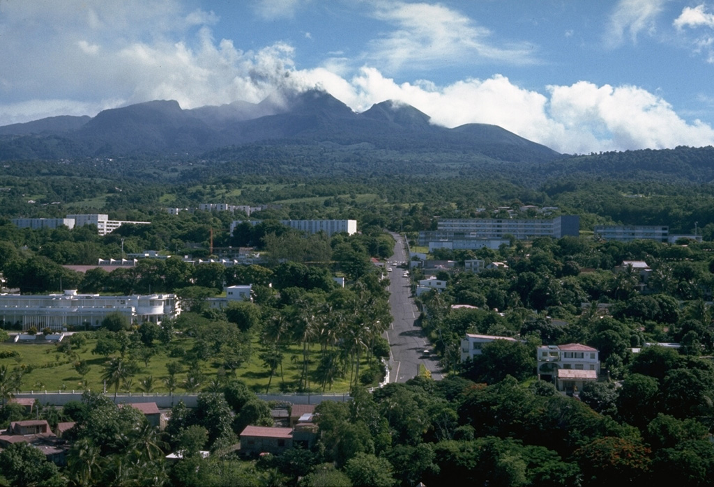
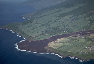
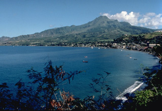
 Mount Pelée towers above the city of St. Pierre (on the coast at the left), which the volcano destroyed during a catastrophic eruption in 1902. Pelée is the most active volcano of the Lesser Antilles arc, with more than 20 major eruptions during the past 5000 years. The modern volcano was constructed on the rim of a large SW-facing horseshoe-shaped caldera whose northern wall is the ridge in the shadow on the left horizon. This caldera formed as a result of slope failure of the paleo-Pelée volcano.
 Photo by Richard Fiske, 1977 (Smithsonian Institution).
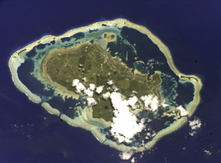 A barrier reef surrounds the Wallis Islands in this International Space Station view (N is to the left). Small explosion craters are visible on the 7 x 14 km Uvea Island. Uvea and the other low forested islands within the barrier reef are formed of flat-lying basaltic lava flows that are cut by explosion craters and capped by tuff cones and the scoria cones. Tuff cones and other features were considered to have been formed during the Pleistocene and Holocene based on morphology.
NASA International Space Station image ISS002-E-9888, 2001 (http://eol.jsc.nasa.gov/).
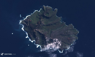
 The 17.5-km-wide Ile de l' Est in the Crozet Archipelago is shown in this combined March 2020/February 2021 Planet Labs satellite image monthly mosaics. The island is largely eroded by glaciation and also contains younger scoria cones, most of which are on the eastern side.
Satellite image courtesy of Planet Labs Inc., 2021 (https://www.planet.com/).
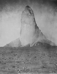 Slow, piston-like extrusion of a solidified portion of a lava dome sometimes produces vertical lava spines that rise above the surface of the dome. The world's largest known spine rose to a maximum height of 350 m, more than twice that of the Washington Monument, at Mount Pelee on Martinique in 1903. Growth of the spine began in November 1902 and reached its maximum on May 31, 1903. It slowly disintegrated and was gone by the end of the eruption two years later. This photo was taken on March 15, 1903.
From the collection of Maurice and Katia Krafft.
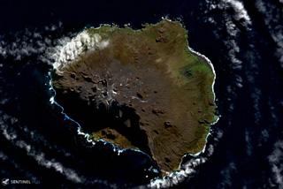
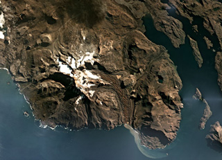 The Kerguelen Islands are part of an extensive Large Igneous Province, and are composed largely of extensive lava flows, exposed intrusive rock, and several volcanic centers such as Mount Ross which is shown in this April 2019 Planet Labs satellite image monthly mosaic (N is at the top; this image is approximately 30 km across). The Buffon glacier is on the eastern flank and immediately E of where it turns S is the flat-topped remnant of a lava lake.
Satellite image courtesy of Planet Labs Inc., 2019 (https://www.planet.com/).
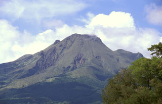 The 1929 lava dome forms the summit of Mount Pelée in this telephoto view from St. Pierre. The modern volcano was constructed within a scarp produced by collapse of the volcano about 9000 years ago. The irregularity on the right-hand flank is part of the eastern summit crater rim and the Aileron lava dome, which erupted about 9700 years ago.
 Photo by Paul Kimberly, 2002 (Smithsonian Institution).
 This view looks west from the 1902 lava dome within the summit crater of Mount Pelée. The area beyond the grassy knoll was part of the first portion of the ancestral volcano that underwent massive edifice collapse more than 100,000 years ago. This massive collapse produced a 25 cu km debris avalanche that swept into the Caribbean Sea up to 70 km from the coastline. Mount Pelée was subject to three major episodes of edifice collapse--the second took place about 25,000 years and the third about 9000 years ago.
 Photo by Paul Kimberly, 2002 (Smithsonian Institution).
 The central part of the Chaîne des Puys volcanic chain in the Auvergne region of France from the SW. Puy de Dôme is the rounded peak in the center, Puy de Côme is at the left, and Puy de Laschamp is the scoria cone at the right. The N-S-trending chain of basaltic and trachytic cones, basaltic maars, and trachytic lava domes in France's Massif Central has been active into the Holocene. The latest well-documented activity took place about 6,000 years ago.
Photo by Ichio Moriya (Kanazawa University).
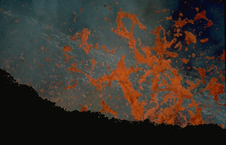
 A black lava flow, one of only six erupted in historical time from vents outside the caldera of Piton de la Fournaise, reached the sea in April 1977, forming a new lava delta. Following minor lava ejection that began on March 24-25 SE of Dolomieu crater, lava effusion began April 5-7 from several vents on the NE flank. The resulting lava flows, active until April 16, burned sugar cane fields and destroyed houses in the town of Piton Ste Rose before reaching the sea below the town.
Copyrighted photo by Katia and Maurice Krafft, 1977.
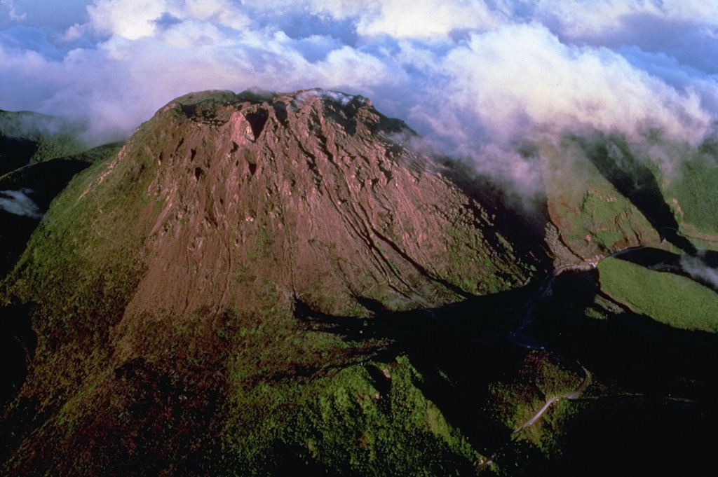
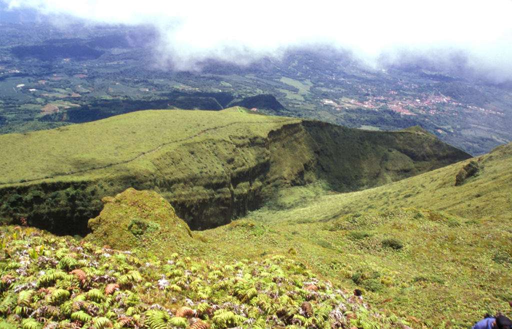
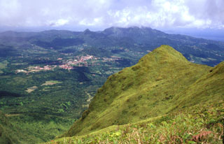
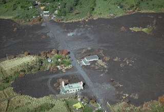
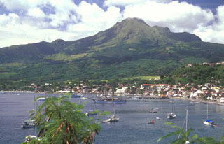
 The summit dome of La Soufrière is seen in the center of this October 1976 aerial view from the SW. The peak at the right is l'Echelle, a scoria cone that is thought to have formed about 1500-2000 years ago. Historical eruptions from the volcano have originated from fissures cutting across the summit dome and its upper flanks.
Photo by Richard Fiske, 1976 (Smithsonian Institution).
 The steep-sided grassy knob in the right foreground is part of the Aileron lava dome, which formed during an eruption about 9700 years ago. This view looks to the SE towards the town of Morne Rouge (left-center), which was devastated by pyroclastic flows during the 1902 eruption. The Pleistocene Piton du Carbet volcano lies in the clouds on the right-center horizon.
Photo by Lee Siebert, 2002 (Smithsonian Institution).
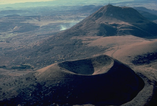
 During a six month period beginning in July 1972, eruptions took place from vents on the south, SE, NE, and north sides of the summit lava shield of Piton de la Fournaise. This aerial view from the south in November 1973 overlooks circular Bory (left center) and oval-shaped Dolomieu (right center) craters. The unvegetated lava flows in the foreground were erupted from circumferential fissures during the 1972 eruption. The dark lava flow at the upper right, beyond Bory and Dolomieu craters, also was erupted in 1972.
Copyrighted photo by Katia and Maurice Krafft, 1973.
 The volcanic units of Ile de la Possession largely formed between around 5 and 0.5 million years ago, shown in this 30 March 2019 Sentinel-2 satellite image (N is at the top). The island is part of the Crozet Archipelago and has been through five main cycles of eruptive activity and erosion including glacial valley formation. More recently, scoria cones and lava flows formed, as well as the collapse of part of the western flank.
Satellite image courtesy of Copernicus Sentinel Data, 2019.
 A lava flow that originated from a vent at 700-m altitude on the outer NE flank of Piton de la Fournaise volcano on 9 April 1977, cut the principal road around Réunion Island and destroyed 12 houses in the village of Piton Ste Rose. The flow traveled 6 km before reaching the sea. About 2500 people were evacuated from the town. A new fissure opened up at 600-m altitude on the 9th. It fed a lava flow that burned more than 20 more houses before the eruption ended on 16 April.
Copyrighted photo by Katia and Maurice Krafft, 1977.
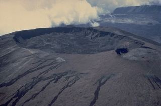
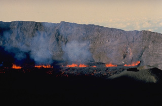 Lava fountains rise above a fissure vent on the floor of the caldera of Piton de la Fournaise volcano on Réunion Island in September 1985. This eruptive phase occurred from vents at 2200-m altitude on the east flank of Dolomieu crater, the central crater of Piton de la Fournaise, near the beginning of an eruption that lasted from June 1985 until December 1988. Fissures both within the caldera and on its outer flanks were active during this eruption.
Copyrighted photo by Roland Benard, 1985 (courtesy of Katia and Maurice Krafft).
 Lava fountains rise along an eruptive fissure cutting the north flank of Dolomieu crater on Piton de la Fournaise in August 1985, during one of the early stages of an eruption that lasted until 1988. Steam clouds at the upper left mark the higher part of the eruptive fissure, which extends radially away from the crater rim. Incandescent lava flows fed from the fissure are visible at the left center and behind the steam clouds.
Copyrighted photo by Roland Benard, 1985 (courtesy of Katia and Maurice Krafft).
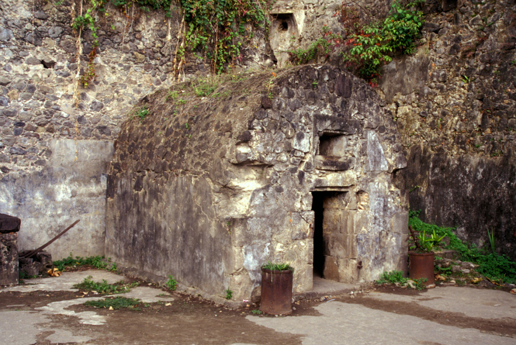
 La Soufrière lava dome, forming the summit of Soufrière Guadeloupe volcano, was emplaced at the end of a major eruption that took place around the mid-15th century. The eruption began with collapse of part of a previous lava dome forming a debris avalanche, followed by a major explosive eruption in which dacitic pumice and andesitic banded scoria were sequentially ejected. The eruption concluded with growth of La Soufrière summit lava dome, which is seen here from the north.
Photo by Paul Kimberly, 2002 (Smithsonian Institution).
 An ash plume rises above the summit of Soufrière volcano on Guadeloupe Island in October 1976 with the deserted streets of Basse-Terre, the island's capital city, in the foreground. The 72,000 inhabitants of Basse-Terre had been evacuated since August because of concern of larger eruptions. In November the evacuation was ended.
 Photo by Richard Fiske, 1976 (Smithsonian Institution).
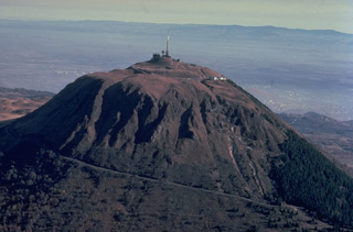 Puy de Dôme (1464 m), the highest peak of the Chaîne des Puys volcanic field, originated during a series of eruptions about 10,000 years ago. Explosive destruction of the eastern side of a massive lava dome, whose western face is seen in this photo, was followed by growth of a second dome. Crumbling of a spine capping the second dome formed the low mound of breccia at the summit of Puy de Dôme, which has been covered by a pyroclastic-flow deposit from nearby Killian volcano.
Copyrighted photo by Katia and Maurice Krafft, 1978.
 The Chaîne des Puys is a N-S-trending chain of cones, maars, and lava domes in the Auvergne region of France. The Puy de Pariou crater in the foreground is a tuff cone that grew about 8,200 years ago within an earlier tuff ring, whose rim appears immediately behind Pariou crater. A lava flow traveled 8 km W to near the present-day city of Clermont-Ferrand. The sharper peak in the background is Puy de Chopine, whose complex history ended with domal uplift.
Photo by Loïc Jahan (Parc de Volcans, published in Green and Short, 1971).
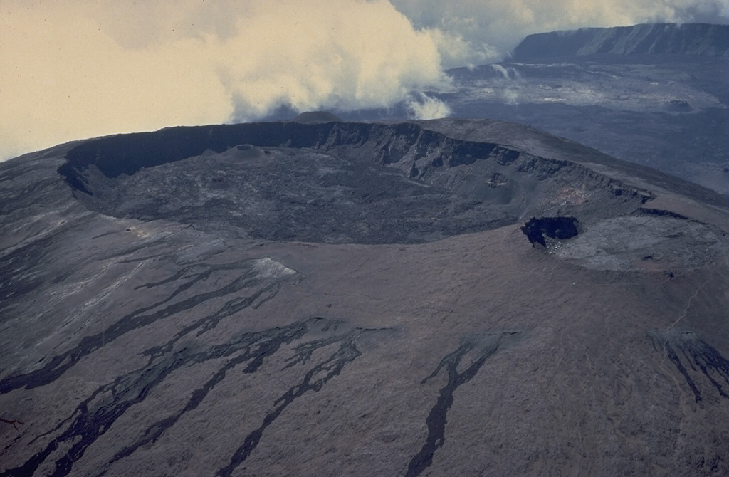
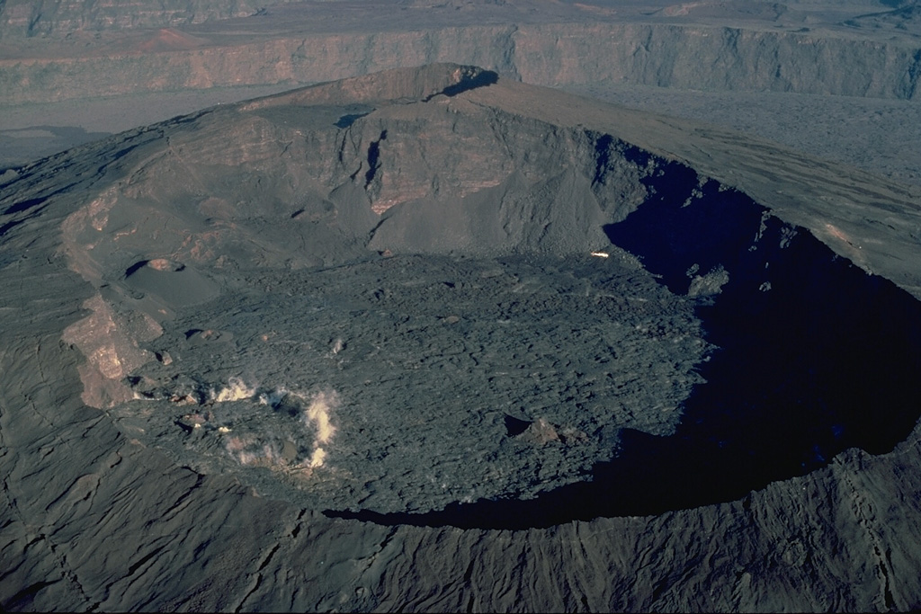
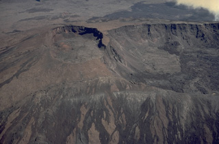
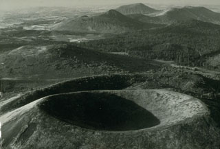
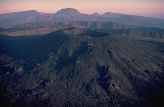
 Oval-shaped Dolomieu crater, seen here in a 1973 aerial view from the NE, truncates the summit of a large lava shield that has grown in the summit caldera of Piton de la Fournaise volcano. The southern wall of the 8-km-wide caldera is visible at the upper right. The eastern rim of the smaller Bory crater at the right center is cut by Dolomieu crater. The unvegetated lava flows in the foreground originated in historical time from circumferential fissures near the summit of the lava shield.
Copyrighted photo by Katia and Maurice Krafft, 1973.
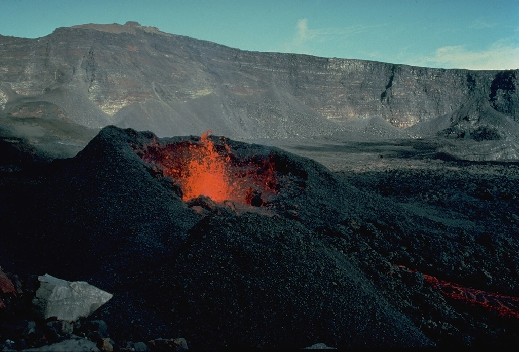
 Incandescent spatter rises above a vent in January 1984. Effusive and explosive eruptions took place December 4, 1983-January 18, 1984 and January 18-February 18, 1984 from fissure vents 400 m apart on the SSW flank of the central lava shield of Piton de la Fournaise. Two cinder cones formed above the vents, located at 2200-m altitude. They produced lava flows that traveled down the SE flank.
Copyrighted photo by Katia and Maurice Krafft, 1984.
 This view from the summit of Mount Pelée shows the eastern rim of l'Etang Sec, the current summit crater of Mount Pelée. The 1902 and 1920 lava domes fill much of this crater. The town with reddish roofs at the far right is Morne Rouge, affected by pyroclastic flows from the 1902 eruption.
Photo by Paul Kimberly, 2002 (Smithsonian Institution).
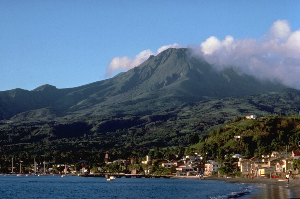
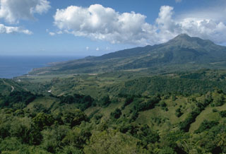
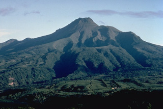
 The deceptively serene-looking Pelee volcano towers above the Caribbean city of St. Pierre, located only 7.5 km to its south. Nearly 30,000 people of St. Pierre and surrounding towns were killed by pyroclastic flows and surges from Mount Pelee in 1902. The long ridge extending SW from Pelee is the northern wall of a large horseshoe-shaped caldera created by a massive volcanic landslide during the Pleistocene. The modern Pelee volcano, capped by lava domes from the 1902 and 1929 eruptions, was constructed within this scarp.
 Copyrighted photo by Katia and Maurice Krafft, 1988.
 This shadows captured in this Sentinel-2 satellite image acquired on 19 May 2019 (N is at the top) highlights the steep southern cliffs of Ile aux Cochons. The 10-km-wide island has preserved scoria cones with craters across the landmass.
Satellite image courtesy of Copernicus Sentinel Data, 2019.
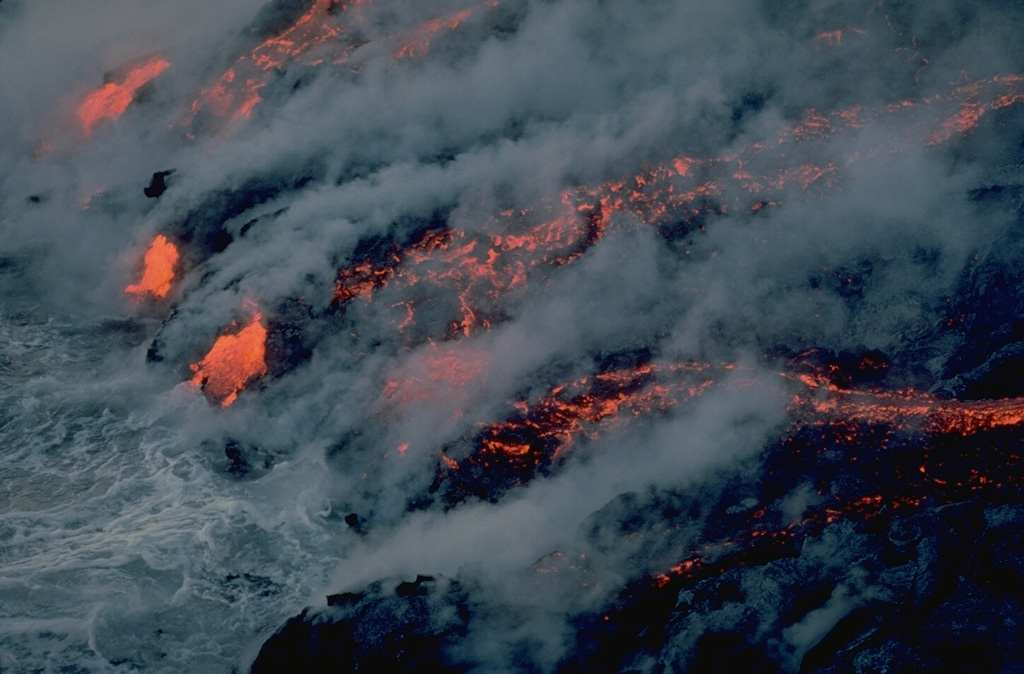
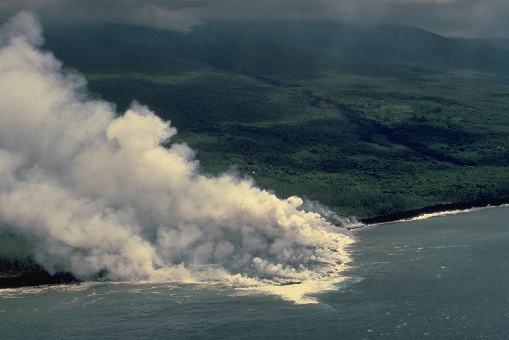
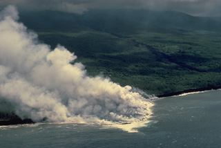 Steam clouds pour from a lava flow entering the Indian Ocean on the SE flank of Piton de la Fournaise volcano in April 1986. The flow originated from a fissure near the coast that opened on March 23. Another SE-flank fissure began on March 20 at 1000-m altitude near Piton Takamaka and produced a lava flow that diverged around the Piton Takamaka cone. The northern lobe traveled more than 4 km to the sea, destroying 8 houses, while the southern lobe stopped only 250 m from the ocean.
Copyrighted photo by Katia and Maurice Krafft, 1986.
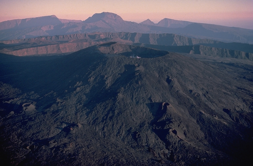
 Dolomieu crater (center) caps the summit lava shield of Piton de la Fournaise volcano. This 1987 aerial view shows the scarps of two large calderas formed by eastward landsliding of the summit of the volcano. The more distant caldera formed about 65,000 years ago, and the closer one, inside which the modern lava shield was constructed, originated less than 5000 years ago. Unvegetated fissure-fed lava flows mantle the flanks of the lava shield. The deeply dissected Pleistocene Piton des Neiges shield volcano forms the western horizon.
Copyrighted photo by Katia and Maurice Krafft, 1987.
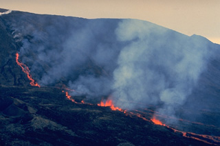
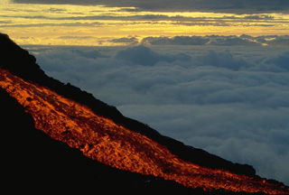 A glowing lava flow descends the flank of Piton de la Fournaise volcano at dawn in September 1985. A long-term eruption that began in June 1985 and lasted until December 1988 produced lava flows from vents within the summit crater of Dolomieu, on its flanks, and on the outer SE flank of the volcano. This was the first outer flank activity since 1977. The SE-flank lava flows destroyed eight houses before reaching the Indian Ocean.
 Copyrighted photo by Roland Benard, 1985 (courtesy of Katia and Maurice Krafft).
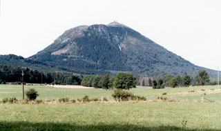 The southern flanks of Puy de Dôme, the highest peak of the Chaîne des Puys volcanic chain, rises above farmlands. Puy de Dôme originated during a series of eruptions about 10,000 years ago. Explosive destruction of the eastern side (right) of a massive lava dome was followed by growth of a second dome. Crumbling of a spine capping the second dome formed the low mound of breccia at the summit of Puy de Dôme, which has been covered by a pyroclastic flow deposit from nearby Killian volcano.
Photo by Ichio Moriya (Kanazawa University).
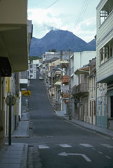 A steam-and-ash plume from the summit of La Soufrière volcano rises above the deserted streets of Basse-Terre in October 1976. Intense controversy surrounded the evacuation of 72,000 people living on the flanks of the volcano. The evacuation, which had resulted in major economic and social disruption, was officially ended in November. This eruption ended without catastrophe, unlike another West Indies eruption two decades later, when the evacuated capital city of Montserrat was devastated by pyroclastic flows.
Photo by Richard Fiske, 1976 (Smithsonian Institution).
 The Puy de Pariou cinder cone in the foreground and the Puy de Dôme lava dome in the background are part of a long N-S chain of volcanoes forming the Chaîne des Puy volcanic field in west-central France. The Puy de Pariou was formed about 8200 years ago inside a tuff ring from an earlier eruption whose rim can be seen at the lower right.
Copyrighted photo by Katia and Maurice Krafft, 1978.
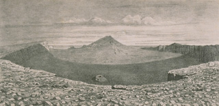
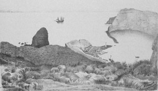 A small 1.8-km-wide caldera cuts the E side of uninhabited St. Paul Island, as depicted in this plate from the SMS Gazelle expedition. The flooded caldera has 300-m-high walls on the SW side and is narrowly constrained by low spits on the NE. Geothermal areas are located along the caldera rim and along the margins of the caldera bay. The entire NE half of the volcano forming much of the island now lies beneath the sea.
Plate from the SMS Gazelle expedition (courtesy of NOAA Photo Library).
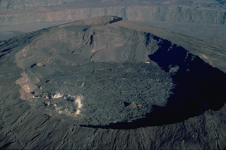 Dolomieu crater, seen here from the east in 1987, forms the principal summit crater of Piton de la Fournaise volcano. The western wall of Dolomieu crater cuts the rim of the smaller Bory Crater. Dolomieu crater, whose form has varied widely during the course of historical eruptions, dates back to July 1791. Twentieth-century lava flows cover the floor of the crater. The western wall of the most recent caldera of Piton de la Fournaise is visible in the distance.
Copyrighted photo by Katia and Maurice Krafft, 1987.
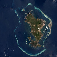 Mayotte consists two main volcanic islands, Grande Terre and Petite Terre, and around twenty islets within a barrier-reef lagoon complex approximately 38 km across, shown in this Planet Labs satellite image monthly mosaic (N is at the top). Recent activity has occurred offshore, 50 km E.
Satellite image courtesy of Planet Labs Inc., 2018 (https://www.planet.com/).
 The twin breached cinder cones of Puy de Lassolas (left) and Puy de la Vache (right) were formed during eruptions about 8000 years ago. The cones were breached when moving lava flows carried away portions of them. A compound lava flow from the two cones traveled 14 km to the SE. The high peak in the distance to the north is the Puy de Dôme lava dome.
Copyrighted photo by Katia and Maurice Krafft, 1978.
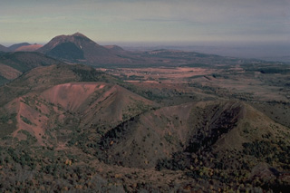
 The massive Piton de la Fournaise on the island of Réunion is one of the world's most active volcanoes. It is seen here in 1977 with a black lava flow descending the outer NE flank to the sea. The unvegetated summit (top left) was constructed within an 8-km-wide caldera that is breached to the sea. Its sloping N rim is marked by the diagonal vegetation line at the left. More than 150 eruptions have occurred since the 17th century, mostly from vents within the caldera.
Copyrighted photo by Katia and Maurice Krafft, 1977 (published in SEAN Bulletin, 1977).
 A 19th-century lithograph looking from the WNW rim shows the morphology of the summit crater of Piton de la Fournaise in 1885. Between 1817 and 1925, there were three summit craters. Piton Bory (center horizon) occupied the central crater, a large basin called Enclos Velain. It was located between Bory crater (foreground) and Dolomieu crater, which is out of view behind Piton Bory. The shape and size of the summit crater complex has varied widely during the course of the volcano's frequent historical eruptions.
Lithograph by A. Roussin, 1885 (from the collection of Maurice and Katia Krafft).
 Mount Pelée towers above the city of St. Pierre in northern Martinique a century after the catastrophic eruption that destroyed the city in 1902. Pelée is the most active volcano of the Lesser Antilles arc, with more than 20 major eruptions during the past 5000 years. Lava domes formed during the 1902 eruption and one in 1929 form the present summit, which was constructed within a large scarp visible on the lower left horizon that formed when the volcano collapsed about 9000 years ago.
 Photo by Lee Siebert, 2002 (Smithsonian Institution).
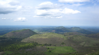 Part of the Chaîne des Puys volcanic field is shown in this May 2016 view from the Puy de Dome. The N-S trending volcanic chain includes around 80 lava domes, scoria cones, and maars, several of which are seen here.
Photo by Arianna Soldati, 2016.
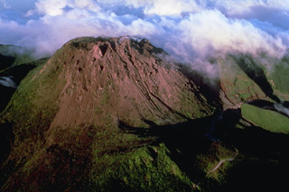
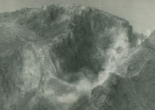
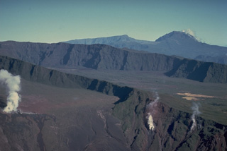 Steam rises from fumaroles on the walls of Bory (left center) and Dolomieu (lower right) craters. The two craters occupy the summit of a Holocene lava shield that was constructed within an 8-km-wide horseshoe-shaped caldera, whose NE rim forms the steep wall in the background. Lava flows covering the NE part of the caldera are older than those on the eastern and southern sides of the caldera, where historical lava flows blanket most of the caldera floor. The deeply dissected Pleistocene Piton des Neiges shield volcano forms the horizon.
Copyrighted photo by Katia and Maurice Krafft, 1977.
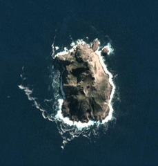 The roughly 1.1 x 0.8 km Hunter Island in the SE New Hebrides arc is shown in this 14 May 2020 PlanetScope satellite image (N is at the top). Several craters have formed across the island and geothermal activity has been noted on the N, NE, and SE coasts.
Satellite image courtesy of Planet Labs Inc., 2020 (https://www.planet.com/).
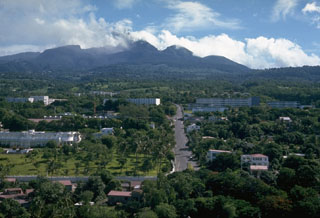
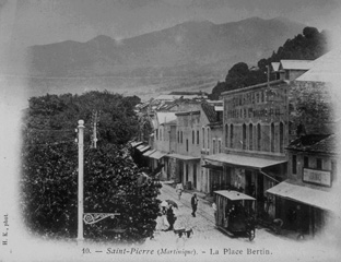 Prior to the 1902 eruption, St. Pierre was the largest and most beautiful city of the Lesser Antilles. The forested slopes of the seemingly benign Mount Pelee provided a scenic backdrop to the thriving commercial center on the NW coast of Martinique. The last eruption a half-century earlier had been a modest one, and even after the first explosions began on April 23, there was little concern. No volcanological studies had been made, and official statements of reassurance kept most residents in the city until the devastating eruption of May 8.
From the collection of Maurice and Katia Krafft.
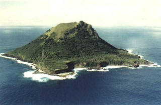 The 1.5-km-wide, steep-sided island of Meheti’a, seen here from the south, is the youngest and SE-most of the Society Islands. Wave erosion has exposed older lava flows, leaving steep cliffs that overlie coral reefs.
 Photo by Jacky Vedraine (http://www.polynesiepassion.net).
 The steep-sided, flat-topped summit lava dome of Soufrière de la Guadeloupe volcano is seen here in a 1981 aerial view from the SW. The dome was emplaced at the end of a powerful explosive eruption about 500 years ago. Most historical eruptions have originated from fissures cutting the summit and flanks of the dome. The 1976-77 eruptions originated from a fissure cutting across the summit from the NW to the SE (right) flank.
Copyrighted photo by Katia and Maurice Krafft, 1981.
 Mont Pelee, seen here from the south, has a complex summit morphology. The eastern rim of the summit crater, the 1-km-wide Caldeira de l'Etang Sec, forms the notch just to the right of the summit. This crater cuts an edifice that was constructed within a larger horseshoe-shaped caldera, breached to the SW. It was formed during the Pleistocene as a result of a massive volcanic landslide. Two historical lava domes largely fill the Caldeira de l'Etang Sec. The 1929 lava dome forms the summit; the 1902 lava dome is out of sight behind it.
 Copyrighted photo by Katia and Maurice Krafft, 1981.
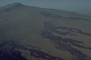 A series of en echelon fissures cutting the upper NE flank of the central lava shield of Piton de la Fournaise volcano fed these black, unvegetated lava flows that descend the flanks of the volcano. Most of the eruptions of Piton de la Fournaise, one the world's most active volcanoes, originate from fissure vents. Circumferential fissures such as these occur near the crater rim; more commonly radial fissures extend down the flanks perpendicular to the summit crater rim.
Copyrighted photo by Katia and Maurice Krafft, 1976.
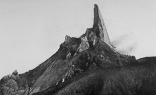 One of the most dramatic events following the devastating 1902 eruptions of Mount Pelee in Martinique was the growth of a towering spine on the summit lava dome. It began to rise above the dome on November 3, 1902. By May 31, 1903, the spine reached a height of 350 m above the dome, temporarily creating a 1617-m-high peak at the summit. It then slowly disintegrated and was gone by the end of the eruption. This March 11, 1903, photo shows the spine near its peak height, with a smoothly extruded eastern side.
Photo by A. Lacroix, 1903 (from the collection of Maurice and Katia Krafft).
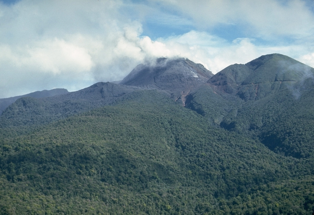
 On 27 November 1976 a plume, water discoloration, and sulfur odor were reported from Matthew Island. It was later noted that no noticeable eruptive event or change in island morphology had occurred since 1958. This February 1977 photo shows the steaming crater of Matthew Island volcano.
Photo by Royal New Zealand Air Force, 1977.
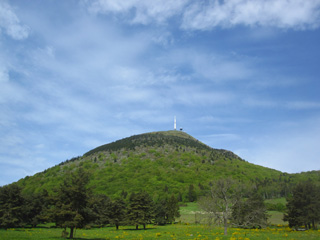 The 500-m-high Puy de Dôme of the Chaîne des Puys volcanic field formed around 11,000 years ago. The dome, with a diameter of 1.5-2 km, is surrounded by pyroclastic density current deposits.
Photo by Arianna Soldati, 2016.
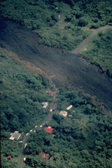 A lava flow from a vent that opened on 20 March 1986 at 1000-m altitude on the outer SE flank of Piton de la Fournaise cut a road and destroyed 8 houses, leaving 51 people homeless. This photo was taken two days later on 22 March. This lava flow was produced during a long-term eruption that took place from June 1985 to December 1988 from vents both within and outside the caldera.
Copyrighted photo by Katia and Maurice Krafft, 1986.
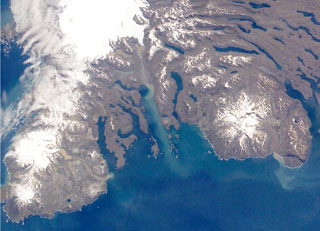 The Rallier du Baty Peninsula (bottom left) forms the SW tip of Kerguelen Island. It contains two subglacial eruptive centers, Mont St. Allouarn and Mont Henri Rallier du Baty. An active fumarole field is related to a series of Holocene trachytic lava flows and lahars that extend beyond the icecap. The snow-covered peak at the mid-right is late-Pleistocene Mount Ross stratovolcano. The Kerguelen Islands are composed primarily of Tertiary flood basalts and a complex of plutonic rocks extensively modified by glaciation.
NASA International Space Station image ISS005-E-21805, 2002 (http://eol.jsc.nasa.gov/).
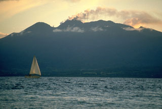 La Soufrière volcano, the highest in the West Indies, is a complex stratovolcano that dominates the southern end of Basse-Terre, the western half of the butterfly-shaped island of Guadeloupe. A steam-and-ash column rises above the summit in this October 1976 view from the NE at Pointe-a-Pitre, on the isthmus connecting the island segments. The peak at the left (above the sailboat), l'Echelle, is a young cinder cone; the summit itself is a 500-year-old lava dome, and remnants of older collapsed volcanoes are located to its right.
Photo by Richard Fiske, 1976 (Smithsonian Institution).
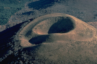 Puy de Dôme, in the France's Chaîne des Puys volcanic field, is a beautiful example of a nested pair of craters. The symmetrical crater at the summit of the cinder cone was formed by late-stage eruptions that built the small cone inside a larger crater rim produced by older eruptions.
Copyrighted photo by Katia and Maurice Krafft.
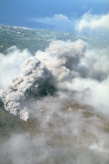 An ash column rises above a fissure on the upper NW flank of La Soufrière de la Guadeloupe volcano in October 1976, with the capital city of Basse-Terre in the background. Intermmitent mild-to-moderate phreatic explosions took place from July 8, 1976, to March 1, 1977. Concern about the possibility of a larger eruption prompted the evacuation of the capital city of Basse-Terre from August to November 1976.
 Photo by Richard Fiske, 1976 (Smithsonian Institution).
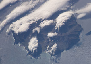 Ile de l'Est, the easternmost island in the Crozet archipelago, is seen in this NASA International Space Station image (N to the top). The glacially-eroded volcano contains about a half dozen young scoria cones of possible Holocene age concentrated on its E flank. Cape Itaine forms the small peninsula on the SW side of the island (bottom left), and Abondance Bay is at the bottom center.
NASA International Space Station image ISS006-E-37992, 2003 (http://eol.jsc.nasa.gov/).
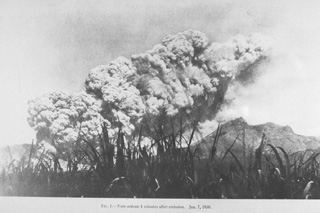 A pyroclastic flow produced by the collapse of a growing lava dome in the summit crater, sweeps down the SW flank of Mount Pelee on 1 January 1903. Small pyroclastic flows continued for 16 months following the catastrophic eruption of 8 May 1902, that destroyed St. Pierre. A second large pyroclastic flow, comparable in size to that of 8 May, devastated the SE flank on 30 August, killing an additional 1500 people. The frequency of pyroclastic flows diminished after September 1903, but they continued at longer intervals until October 1905.
Photo by Hayot, 1903 (from the collection of Maurice and Katia Krafft).
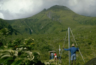 The summit of Pelée volcano rises immediately above scientists from the Mount Pelée volcano observatory and the Smithsonian Institution who are taking precision leveling measurements on the west flank. This procedure, sometimes referred to as "dry tilt," detects deformation of the volcano that often precedes an eruption by measuring the precise differences in elevation between two stadia rods placed on fixed points. This technique is part of monitoring efforts by the observatory to help detect future eruptions of this scenic, but deadly volcano.
Photo by Lee Siebert, 1977 (Smithsonian Institution).
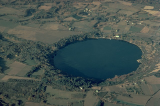 The Gour de Tazanet maar is the northernmost volcano of the Chaîne des Puys volcanic field in central France. The lake-filled explosion crater, one of many maars in the volcanic field, was formed when magma came in contact with groundwater. Rhythmic ejection of fragments of nonvolcanic rock produced bedded ash deposits and formed a low-rimmed crater, 700-m wide and 66-m deep.
Copyrighted photo by Katia and Maurice Krafft.
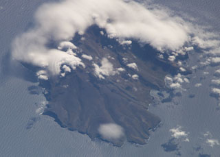 Ile de la Possession, located immediately west of Ile de l'Est in the Crozet archipelago, is seen in this NASA International Space Station image (N at the top). The 14 x 19 km island is structurally complex and has an irregular shoreline. It consists of a stratovolcano intruded by ring and cone dikes and modified by block faulting, marine erosion, and uplift. Young scoria cones of probable Holocene age are distributed over much of the island.
NASA International Space Station image ISS006-E-37990, 2003 (http://eol.jsc.nasa.gov/).
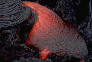 A lobe of ropy pahoehoe lava slowly oozes across the surface of a lava flow at Piton de la Fournaise volcano in the Indian Ocean in March 1976. The wrinkled surface of pahoehoe lava forms when the still molten interior advances, dragging along the solidifying crust of the flow. Areas of incandescent lava can be seen between the surface coils of the more solidifed lobe at the upper left.
 Copyrighted photo by Katia and Maurice Krafft, 1976.
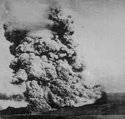 A pyroclastic flow, similiar to the one that destroyed the city of St. Pierre on Martinique on May 8, 1902, sweeps down the flanks of Mount Pelee volcano on December 16, 1902. A towering column of ash and steam rises above the advancing pyroclastic flow, which was formed by collapse of gas-rich rocks on a growing lava dome in the summit crater. The May 8 pyroclastic flow was substantially larger than this one, and would have covered an area wider than the entire shoreline of this photo.
Photo by A. Lacroix, 1902 (from the collection of Maurice and Katia Krafft).
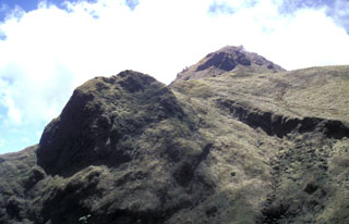 The steep-sided lava dome at the left is Aileron, which was formed about 9700 years ago. The back side of the dome was cut by the latest of three major edifice-collapse events at Mount Pelée. The eastern rim of l'Etang Sec, the current summit crater, cuts horizontally across the photo at the upper right in front of the 1929 dome on the right horizon.
Photo by Lee Siebert, 2002 (Smithsonian Institution).
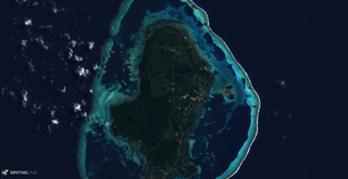 The main 7 x 14 km Uvea Island and 22 smaller islands that make up Wallis Islands are surrounded by a reef reaching approximately 18 km across (E-W), seen here in this 29 August 2018 Sentinel-2 satellite image. The island contains lava flows, craters, and scoria cones, with some craters containing lakes.
Satellite image courtesy of Copernicus Sentinel Data, 2018.
 Steam clouds pour from an incandescent lava flow entering the Indian Ocean on March 25, 1986. This flow, part of a long-term eruption during 1985-88, originated on March 23, 1986 from vents located at less than 100-m altitude. This eruption was one of only six historical eruptions at Piton de la Fournaise volcano to originate from vents on the outer flanks.
Copyrighted photo by Katia and Maurice Krafft, 1986.
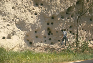 This photo portrays an unusual combination of geology and history. The light-colored deposits in this outcrop south of St. Pierre are pyroclastic-flow deposits similar to those of eruptions that destroyed the city in 1902. The abundant large holes in the outcrop are not a volcanological phenomenon, but were produced by cannon balls blasted into the unconsolidated deposit during British-French wars for control of the island of Martinique.
 Photo by Richard Fiske, 1977 (Smithsonian Institution).
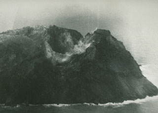 Matthew Island is composed of two cones separated by a narrow isthmus. Only the triangular eastern portion of the small, 0.6 x 1.2 km wide island existed prior to the 1940s, after which eruptions began to build the larger western segment (part of which is seen in the photo). The western cone consists primarily of lava flows and contains a crater that is breached to the NW.
Photo by Royal New Zealand Air Force, 1977.
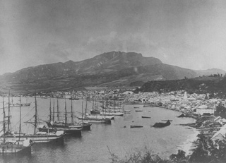 Ships line the harbor of St. Pierre before the catastrophic 1902 eruption. Prior to 1902, St. Pierre was one of the leading ports of the Carribean. At that time Mont Pelee was a forested volcano with a flat-topped summit. Residents and officials of St. Pierre, in the foreground 7.5 km south of the volcano, were not concerned that the volcano posed a threat to the city. Pelee had not erupted since 1851, and only minor phreatic eruptions had occurred then.
From the collection of Maurice and Katia Krafft.
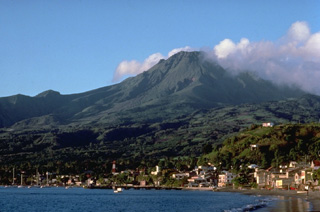 Mount Pelee, the most renowned volcano of the West Indies, towers above the city of St. Pierre, which it destroyed during a major eruption in 1902. Pelee is the most active volcano of the Lesser Antilles, producing at least 20 major explosive eruptions during the past 5000 years. Extensive deposits of pyroclastic flows mantle the volcano. Its present summit consists of lava domes emplaced during eruptions in 1902 and 1929.
 Copyrighted photo by Katia and Maurice Krafft, 1988.
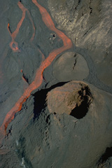 An incandescent lava channel diverts around a lava cone on Piton de la Fournaise volcano in September 1985. A long-term eruption beginning in June 1985 produced more than 0.1 cu km of lava flows from fissures in the summit crater, the flanks of the central lava shield, and the outer flanks of the caldera.
Copyrighted photo by Roland Benard, 1985 (courtesy of Katia and Maurice Krafft).
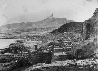 The devastated city of St. Pierre lies in ruins after a catastrophic eruption on 8 May 1902, in which pyroclastic flows and surges swept over the city, killing 28,000 people. The high-temperature pyroclastic surges devastated a 58 km2 area SW of the volcano and swept out to sea, capsizing all but two ships in the harbor. This March 1903 photo from the south shows Mount Pelee towering over the remnants of the city, capped by a dramatic lava spine that grew above the summit lava dome.
 Photo by A. Lacroix, 1903 (from the collection of Maurice and Katia Krafft).
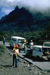 Scientists unload equipment in October 1976 to measure deformation of the volcanic edifice at Savane à Mulets, on the south side of the summit lava dome. This was one of several tools used to monitor the volcano during the 1976-77 eruption.
 Photo by Richard Fiske, 1976 (Smithsonian Institution).
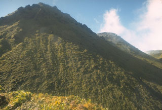 Two lava domes fill much of the Caldiera de l'Etang Sec crater at the summit of Mount Pelee. The lava dome at the left, seen from the east rim of the crater, was formed during an eruption that began in 1929. The vegetated knob halfway down the right skyline is a lava dome from the 1902 eruption. The 1929 eruption was similiar to that of 1902, but smaller in scale. After explosive removal of part of the 1902 dome, growth of a new dome began in January 1930. Pyroclastic flows accompanied dome growth until the end of 1932.
Photo by William Melson, 1973 (Smithsonian Institution).
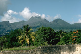 Steam rises from a 500-year-old lava dome that forms the summit of La Soufrière volcano on Guadeloupe. It was constructed within the 1-km-wide, horseshoe-shaped Amic Crater, whose northern rim is the flat-topped ridge at the extreme left. Amic Crater was the source of a major explosion and debris avalanche about 3100 years ago during an eruption that resembled the 1980 Mount St. Helens eruption. The peak to its right is l'Echelle, a young cinder cone. This September 1976 view is from the west.
Photo by Richard Fiske, 1976 (Smithsonian Institution).
 Incandescent lava rises from a spatter cone during an eruption November 4-18, 1975 in Dolomieu crater. Subsequently, from December 18, 1975 to April 6, 1976, explosive and effusive eruptions occurred from fissures at various locations on the SE flank. A January 18-30 lava flow originating from a SE-flank vent at 1320-m altitude traveled 5 km down to 70-m altitude and covered 250 m of the coastal highway.
Copyrighted photo by Katia and Maurice Krafft, 1975.
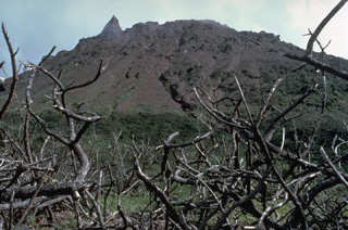 La Soufrière, the summit lava dome of La Soufrière de la Guadeloupe volcano, was formed at the end of a major magmatic eruption about 500 years ago. This 1981 photo shows the craggy andesitic lava dome from Savane à Mulets, SW of the summit.
Copyrighted photo by Katia and Maurice Krafft, 1981.
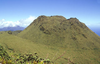 The 1902 lava dome fills much of the l'Etang Sec summit crater, as seen here from Morne Macouba, north of the summit. Following the catastrophic eruption on May 8, 1902, rapid growth of a summit lava dome began; it reached 350 m height by July 6. Intermittent explosive activity continued until October 31, 1903 and lava dome growth continued on a diminishing scale until October 5, 1905. The famous spine at one point rose to 1617 m, 220 m above the current summit (the 1929 lava dome), before it crumbled away.
Photo by Paul Kimberly, 2002 (Smithsonian Institution).
 Amsterdam Island has an asymmetrical profile as seen from the SSE in this plate from the SMS Gazelle expedition. The broad area left of the summit of the island is the remnant of a paleo-caldera; cliffs to the left expose remnants of the Fernand paleo-volcano. Deposits from a younger volcano cover most of the island, and more than two dozen cones occur on its flanks.
Plate from the SMS Gazelle expedition (courtesy of NOAA Photo Library).
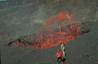 Red-hot ribbons of molten lava hurled above a vent in the Dolomieu summit crater of Piton de la Fournaise volcano in November 1975 are observed at close range by volcanologists Maurice Krafft and Jean-Claude Vallée. These mild eruptions in the summit crater preceded more voluminous lava effusion from flank vents that lasted until April 1976.
Copyrighted photo by Katia and Maurice Krafft, 1975.
 This prison cell in the city of St. Pierre housed one of the only two survivors of the 8 May 1902, eruption of Mount Pelée. Devastating pyroclastic flows and surges swept down the SW flank of the volcano early in the morning and destroyed the city, killing 28,000 people in the world's deadliest eruption of the 20th century.
 Photo by Paul Kimberly, 2002 (Smithsonian Institution).
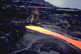 Volcanologist Maurice Krafft photographs a narrow lava flow on Piton de la Fournaise volcano in March 1976, his tripod only a meter away from the incandescent flow margin. Maurice and Katia Krafft observed more eruptions than any other volcanologists, devoting their careers to documenting both the beauty of volcanoes and their hazards. Before losing their own lives in 1991 filming pyroclastic flows on Unzen volcano, they produced videos that alerted officials and the public to the hazards of volcanoes, saving many other lives.
 Copyrighted photo by Katia and Maurice Krafft, 1976.
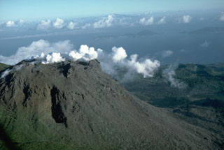 Steam pours from a fissure cutting the summit of La Soufrière in September 1976. Intermittent phreatic eruptions had begun in July and continued until March of the following year. This view from the north shows the Les Santes islands at the right and the tip of Dominica Island in the distance.
 Photo by Richard Fiske, 1976 (Smithsonian Institution).
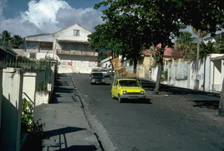 Vehicles laden with possessions are driven down the streets of Basse-Terre in September 1976, during the evacuation of the island's capital city. About 72,000 people living on the slopes of the volcano were evacuated until November 1976, producing significant economic disruption.
Photo by Richard Fiske, 1976 (Smithsonian Institution).
This is a compilation of France volcano information sources, such as official monitoring or other government agencies.
| Volcanic Ash Advisory Center | |
|---|---|
| Toulouse Volcanic Ash Advisory Center (VAAC) Notices and Archive | |